Skip to content
Destinations
Weather & climate
Nature
Outdoors
Culture
Events
Sky & live
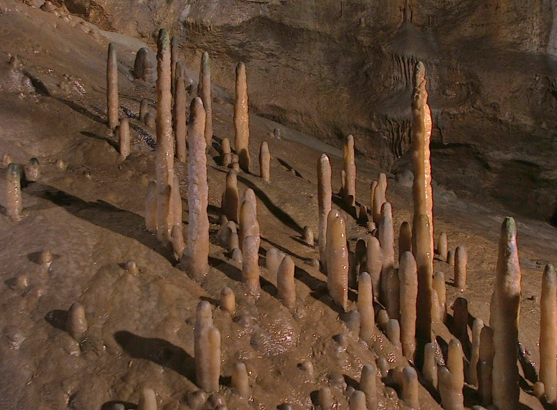
Wundershöhle
Photo: Derzno · CC BY 3.0 · Wikimedia Commons
WundershöhleReport this photo · linked, not stored
Oswaldhöhle
Photo: Derzno · CC BY 3.0 · Wikimedia Commons
OswaldhöhleReport this photo · linked, not stored
Oswaldhöhle
Doktorshöhle
Photo: Derzno · CC BY 3.0 · Wikimedia Commons
DoktorshöhleReport this photo · linked, not stored
Doktorshöhle
St. Lawrence (Muggendorf)
Photo: Derzno · CC BY 3.0 · Wikimedia Commons
St. Lawrence (Muggendorf)Report this photo · linked, not stored
St. Lawrence (Muggendorf)
Rosenmüller Cave
Photo: Derzno · CC BY-SA 4.0 · Wikimedia Commons
Rosenmüller CaveReport this photo · linked, not stored
Rosenmüller Cave
caveGößweinstein, Bavaria

Wundershöhle

archaeological heritage monument in Bavaria
Typecave
Built–
Best monthsJun · Aug–Sepweather in Gößweinstein
49.80° N, 11.27° EUTC+2 · Central European Summer Time
When to goGößweinstein · weather score
JanFebMarAprMayJunJulAugSepOctNovDec39October
Best timeJun · Aug–Sep
October: high / low13° / 5°
iAbout

Wundershöhle in brief

Wundershöhle is a cave in Gößweinstein, Bavaria, Germany.

It holds the designation archaeological heritage monument in Bavaria.

For a visit, the weather in Gößweinstein is best in June, August and September; in October afternoons average 13°.

Gößweinstein: weather and travel guide

Facts

Type
cave
Designation
archaeological heritage monument in Bavaria
Nearest town
Gößweinstein
Region
Bavaria
Coordinates
49.79950, 11.27230
iiLocation

Where to find it

iiiWhen to visit

Weather in Gößweinstein

Climate guide

Month score for sightseeing

Best Jun · Aug–Sep
14
Jan
22
Feb
22
Mar
51
Apr
62
May
65
Jun
64
Jul
68
Aug
71
Sep
39
Oct
20
Nov
13
Dec
ivNearby

More heritage close by

All monuments in Germany
Oswaldhöhle
Photo: Derzno · CC BY 3.0 · Wikimedia CommonsReport this photo · linked, not stored

Oswaldhöhle

under 100 m N
archaeological heritage monument in Bavaria
Oswaldhöhle
Doktorshöhle
Photo: Derzno · CC BY 3.0 · Wikimedia CommonsReport this photo · linked, not stored

Doktorshöhle

0.3 km E
archaeological heritage monument in Bavaria
Doktorshöhle
St. Lawrence (Muggendorf)
Photo: Derzno · CC BY 3.0 · Wikimedia CommonsReport this photo · linked, not stored

St. Lawrence (Muggendorf)

0.8 km NW
architectural heritage monument in Bavaria
St. Lawrence (Muggendorf)
Rosenmüller Cave
Photo: Derzno · CC BY-SA 4.0 · Wikimedia CommonsReport this photo · linked, not stored

Rosenmüller Cave

1.3 km NW
archaeological heritage monument in Bavaria
Rosenmüller Cave
Quackenschloss Cave
Photo: Derzno · CC BY-SA 3.0 · Wikimedia CommonsReport this photo · linked, not stored

Quackenschloss Cave

1.6 km SE
natural monument in Germany
Quackenschloss Cave
Druidenhain
Photo: AndreasH · CC BY-SA 2.0 de · Wikimedia CommonsReport this photo · linked, not stored

Druidenhain

1.7 km SW
natural monument in Germany
Druidenhain
Around here

Gößweinstein and around

Gößweinstein
Photo: ermell · CC BY-SA 4.0 · Wikimedia CommonsReport this photo · linked, not stored

Gößweinstein

Bavaria · Germany
Jun · Aug–Sepbest months
24°July high
465 maltitude
Gößweinstein

Nature

Ailsbach
Photo: © Freak-Line-Community / Wikimedia Commons · CC BY-SA 3.0 · Wikimedia CommonsReport this photo · linked, not stored
1.4 km N

Ailsbach

River · 296 m
Ailsbach
Devil's Cave
Photo: Magnus Gertkemper · CC BY-SA 2.0 de · Wikimedia CommonsReport this photo · linked, not stored
6.1 km E

Devil's Cave

Cave · 380 m
Devil's Cave
Aufseß
Photo: Janericloebe · CC BY 3.0 · Wikimedia CommonsReport this photo · linked, not stored
5.5 km NW

Aufseß

River · 358 m
Aufseß

Mountains

Satellite: Sentinel-2 cloudless 2016 by EOX IT Services GmbH · CC BY 4.0 · Contains modified Copernicus Sentinel data 2016
38 km NE

Hohberg

863 m · Fichtel Mountains
Hohberg
Rauher Kulm
Photo: Joshuashearn · CC BY-SA 3.0 · Wikimedia CommonsReport this photo · linked, not stored
37 km E

Rauher Kulm

681 m
Rauher Kulm
Fürstenstein
Photo: Srene-4 · CC BY-SA 3.0 · Wikimedia CommonsReport this photo · linked, not stored
38 km NE

Fürstenstein

675 m · Fichtel Mountains
Fürstenstein

Heritage

Basilica Gößweinstein
Photo: W. Bulach · CC BY-SA 4.0 · Wikimedia CommonsReport this photo · linked, not stored
0.1 km NW

Basilica Gößweinstein

architectural heritage monument in Bavaria
Basilica Gößweinstein
Gößweinstein Castle
Photo: W. Bulach · CC BY-SA 4.0 · Wikimedia CommonsReport this photo · linked, not stored
0.3 km NW

Gößweinstein Castle

architectural heritage monument in Bavaria · 1076
Gößweinstein Castle
Burgstall Oberntüchersfeld
Photo: Sven-121 · CC0 · Wikimedia CommonsReport this photo · linked, not stored
2.4 km NE

Burgstall Oberntüchersfeld

architectural heritage monument in Bavaria · 1240
Burgstall Oberntüchersfeld

Museums

Fränkische-Schweiz-Museum
Photo: Straktur · CC BY 3.0 · Wikimedia CommonsReport this photo · linked, not stored
2.5 km NE

Fränkische-Schweiz-Museum

Fränkische-Schweiz-Museum
Satellite: Sentinel-2 cloudless 2016 by EOX IT Services GmbH · CC BY 4.0 · Contains modified Copernicus Sentinel data 2016
0.2 km NW

Wallfahrtsmuseum Gößweinstein
Wallfahrtsmuseum Gößweinstein
Satellite: Sentinel-2 cloudless 2016 by EOX IT Services GmbH · CC BY 4.0 · Contains modified Copernicus Sentinel data 2016
4.8 km E

Heimatmuseum, Pottenstein

Heimatmuseum, Pottenstein